To the casual observer, Fearnan might appear to be a relatively recent settlement. There are a few older croft properties, but most of the houses in the present-day village were built within the last 50 years.
However, closer examination reveals signs of habitation around the village from as long ago as the Bronze Age (the Boar Stone), from the early Christian era (a grave stone in the burial ground and the font from St Kieran’s church), and from the late medieval period (the Market Cross).


But perhaps the most famous and revealing monuments are physically out of sight – they are the 2 Iron Age crannogs, which lie beneath the waters of the loch, just off-shore from the present-day village. These are the remains of artificial-island dwellings, built and inhabited by a farming community some two and a half thousand years ago.
In the 1980’s, one of these crannogs, Oakbank, was the first underwater site in Britain to be excavated and to do this, new archaeological methods had to be developed for both excavating and recording the findings.
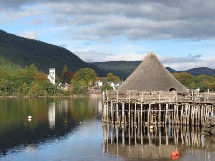
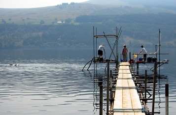
Scottish Crannog Centre, Croft-na-Caber
The excavation has hugely informed the understanding of our Iron Age ancestors, and of life in the Iron Age.
Not only that – it has led to the reconstruction of a crannog, based on the one at Oakbank, on the Loch at Croft-na-Caber. This makes it possible to imagine how Fearnan might have looked 2,500 years ago.
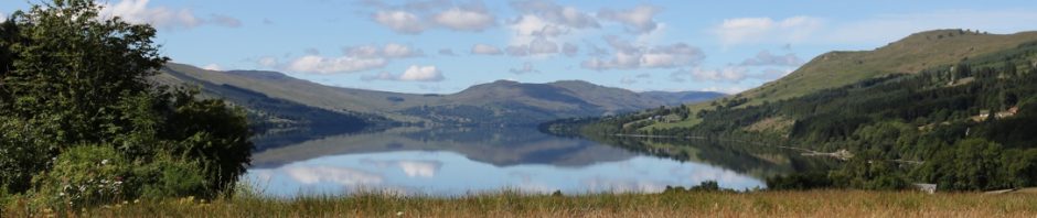
The landscape is not thought to have changed a great deal in the intervening period so, take away the houses in your mind’s eye, and imagine 2 crannogs – one at Oakbank and one just off-shore at Shoreside; you might see smoke seeping through the roofs from the hearths inside the crannogs; you might hear young children playing and see the older children and adults from the extended family watching over grazing animals and tending their crops.
It is the cultivation of the land that creates a direct link between the iron age farmers and Fearnan today, because the present day crofts and houses sit on the same land that was farmed by them 2,500 years ago – and by countless generations both before and since the crannog-dwellers. Once cleared, probably about 3,000 years ago, the fertile land was far too valuable an asset to be abandoned and it has been under continuous cultivation ever since.
Written information about the crannogs starts as far back as 1590. Timothy Pont’s Map of Loch Tay (of which there is a copy in the village hall) refers to “Krannichs”, and the old tradition spoke of 24 artificial islands in the loch. In 1938, William Gillies in his book In Famed Breadalbane, gave the position of 13 of these islands and expressed the opinion that more could be identified by a careful survey.
Forty years later, in 1979, that survey was carried out by Dr Nick Dixon, who is now a Director and founder member of the Scottish Trust for Underwater Archaeology, but at that time he was conducting research at St Andrews University. He identified the remains of 18 crannog sites, all in an excellent state of preservation due to the cold peaty waters of the Loch.
Oakbank Crannog was selected for excavation because of its shape, size and the fact that there were the remains of a walkway from the shore to the crannog. This suggested that, of all the crannogs in the loch, it was most likely to yield interesting information. Today, Nick smiles at this memory, and remarks that if he had known just how much was down there, he might have picked the simplest crannog in the loch instead!
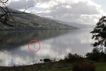
Alder post marking Oakbank Crannog
A single post of alder wood in the water marks the spot where Oakwood Crannog stood. This was put in some 20 years ago, when Nick and his colleagues were experimenting with construction methods ahead of starting the building at Croft-na-Caber. The post was cut to a point and driven into the lochbed. Its continuing presence demonstrates how well the lochbed clays grip and hold structures.
In his book, William Gillies talked of the difficulty of constructing these substantial structures in the Loch. The excavation at Oakbank enabled the archaeologists to determine just how substantial they were. The floor was constructed of three levels of small alder trees lying parallel on top of each other. Around the floor were the upright stakes and piles that supported the walls and roof of the house. Forty elm and oak stumps mark the remains of a walkway that led to the shore.
The archaeologists have found evidence that Oakbank Crannog was rebuilt some 6 times, following the collapse of all or part of the main structure. Each collapse would have added to the growing mound of debris under the crannog, and latterly the support piles that needed to be sunk into the loch would have been driven into the old debris, rather than the lochbed clay. This would have produced a less stable result, and so large stones and rocks were dropped to help hold the piles in place. Over time, a small man-made island would be built up under the crannog.
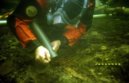
Diver working at Oakbank (photo courtesy of N Dixon)
What is extraordinary is the wealth of information and the sheer volume of artefacts that have been unearthed from what appears to be a mound of stones. Under these stones is a mass of well-preserved organic debris from the crannog’s platform and the dwelling it supported, along with the abandoned material left by the inhabitants. Loch Tay’s waters are dark, peaty and cold and this helps with the preservation of materials. But perhaps the best preserver was the mound of bracken and ferns with which the crannog-dwellers covered their floor to make the building comfortable.
Bracken is full of tannins that have a preserving effect and amongst the bracken and ferns the underwater archaeologists found many of the objects that people had used in their everyday lives. Wooden plates and dishes, the remains of a wooden drinking cup, a wooden spoon, and a butter dish with the remains of butter still sticking to it, have all been uncovered. The discovery of cultivation implements provided evidence of agricultural practice, along with the presence of an early form of wheat. The wheat was unexpected as it had not been thought to be present this far north until some 500 years later.
Animal bones, and sheep droppings with parasite eggs still preserved in them have been found, as well as a fragment of fine textile not suspected from this early date in Scotland.
We now know that their diet included strawberry, blackberry and cloudberry (which only grows on the high moorland above 700m) so the crannog dwellers must have made special trips to collect it. Or perhaps, like the generations of farmers that followed them, they took their sheep up to exploit the higher pastures in summer. Herbs and medicinal plants were also found, and if you have been struggling to eradicate any of these pretty things from your garden…….


…………. you may (or possibly, may not) be interested to know that they have been growing in the area for at least 2,500 years! But then they would have been prized for their medicinal benefits. Fat Hen (chenopodium), so called because it was used to fatten poultry, was used for liver complaints, as a mild laxative, for skin irritations, and for relieving arthritis and rheumatism. Plantain (plantago), apart from being nutritious, has been widely used in poultices and lotions, and has anti-inflammatory effects. It is also rich in tannin and allantoin, both of which help injuries to heal. The uses of buttercups (Ranunculus) include treating headaches and, shingles, and sciatica.
Support platform for underwater excavation of Oakbank Crannog. (Photo courtesy of N Dixon)
The discoveries at Oakbank have not just revealed a wealth of information on how the crannog-dwellers lived as a community, but also on how that community interacted with the outside world. Some of the artefacts found did not originate in the area around Loch Tay – or even in Britain, for that matter. Opium poppy seeds found here, but originating in Afghanistan, must have been traded. A black jet bead, possibly from Whitby, must have been acquired through a trading arrangement. And an iron knife, which would have been a prize possession, must also have been acquired from outside the area. The River Tay provided a trading route and had the potential to connect the crannog-dwellers to traders not just from other parts of Britain, but also from the Continent and beyond. Paddles discovered in the remains of Oakbank Crannog confirm that the water was used as a transport route.
But why were the crannogs built? Were they for defence, or purely practical? There are several possible answers to this. One theory is that it was for security, as the crannog provided a defensible site and a means of keeping their animals safe from on-shore predators. However, it is also clear that the structures would have been highly visible for miles away from the hill tops. Not ideal from the security point of view.
Another possible clue is that at the end of the Bronze Age, which spanned the second millennium BC, there was serious change in the climate and the weather became colder and wetter. This resulted in pressure on the land and resources and led to the construction of different types of structures during the Iron Age such as hillforts, duns and monumental roundhouses.
This is also the period in which crannogs were built. Land that had been laboriously cleared and then cultivated would have become highly valuable for sustaining the community and there was a logic to moving dwelling houses offshore to maximise the space on which crops could be grown and animals grazed.
The fact that these dwellings could have been seen from afar, combined with obvious status symbols that were found during the excavation (for example a bronze swan-necked dress pin dating from 5 – 600 BC), suggests another reason for their construction. The people who occupied the crannogs were relatively wealthy people and so prestige and status may have been behind their construction.
We may never know the definitive answer – but we do know that the Loch holds other tantalising secrets.
One of them is a 12.5 metre log boat that lies on the bottom of the Loch. It dates from around 1,500 BC and therefore sunk to the bottom in an accident some 1,000 years before the crannogs were built. Its significant size suggests that it was used for carrying cargo as well as people.
Discovered in 1994, it has been left in place on the lochbed, where it continues to be preserved by the cold, peaty waters, until technological advances reduce the cost of raising and preserving it on dry land.
Another extraordinary discovery was a submerged Neolithic woodland deep in the Loch. In a 160m strip on the loch bed, divers found well-preserved oak and elm timbers – some fallen, some still upright and protruding from the lochbed. Samples taken indicate the trees are between 8,000 and 1,500 years old and it is thought that this underwater woodland represents the old natural shoreline of the Loch, which would have been some 10 – 15 metres from the current shoreline.
In amongst the submerged woodland, divers also discovered the preserved remains of a 4,000-year-old beavers’ lodge – a somewhat topical find suggesting that beavers can perhaps claim a historical right to be in this area!
This year, the 20th anniversary of the reconstruction of the crannog at Croft-na-Caber, the underwater archaeologists are to return to Oakbank for further excavation work. No doubt more detailed information about iron-age life, concealed and preserved for 2,500 years by the waters of the Loch, will be revealed.
In the meantime, The Scottish Crannog Centre, where more information about the Oakbank excavation can be obtained, re-opens for the season on 1st April 2017.
(Many thanks to Dr Nick Dixon for his time and help in putting this article together.)

Interesting!
Most interesting article. Thank you very much. Somebody [it might have been Nick or Barrie] once told me that the fields between Fearnan and Fortingall could well have been farmed continuously since the Iron Age.
Fran
Sent from my iPad